
The Infrastructure Investment and Jobs Act is the largest investment in climate resilience in U.S. history. The $1.2 trillion in funding will create transformative opportunities for local governments that own and maintain most of the nation’s infrastructure, but first state and federal agencies must ensure the resources get to the places that need it the most. To help identify communities that need support but may lack staff and expertise to compete for federal funding, we have created a first-of-its-kind Rural Capacity Map.
Communities will need capacity—the staffing, resources, and expertise—to apply for funding, fulfill onerous reporting requirements, and design, build, and maintain infrastructure projects over the long term. Many communities simply lack the staff—and the tax base to support staff—needed to apply for federal programs. Even communities that can put together applications are often outcompeted by higher-capacity, coastal cities. The places that lack capacity are often the places that most need infrastructure investments: places with a legacy of disinvestment including rural communities and communities of color.* * *Where is capacity limited?
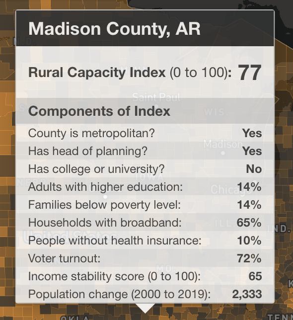
To help identify communities with limited capacity, Headwaters Economics created a new Rural Capacity Index on a scale of 0 (low capacity) to 100 (high capacity). The Index is based on 10 variables that can function as proxies for community capacity. The variables incorporate metrics related to local government staffing, community education and engagement, and socioeconomic trends. (Read more under Data Sources and Methods below.)
I have to admit that I was surprised, as I danced my cursor across Arkansas, in particular the northwest part of the state where I grew up. I was surprised to see my home county, Newton County, designated metropolitan (its population is 8,000 and it is part of the Harrison/Boone County Micropolitan area at best), while neighboring Searcy County to the east, with very similar demographics, is nonmetropolitan. (I did check out the definitions link above, but it doesn't shed any light on Newton County's categorization as metropolitan). I'm also skeptical that 20% of adults in Newton County have higher education because as of 2011, only 12.4% had. bachelor's degree or higher. According to the U.S. Census Bureau, 15.9% of residents now have a bachelor's degree or higher in Newton County. This Rural Capacity Index shows a higher education rate of just 12% for Searcy County, while the Census Bureau indicates 10.9% have at least a bachelor's degree.
 |
| County-level map of northwest and north central Arkansas |
Both Searcy and Newton have long been designated persistent poverty counties, though these snapshots show a much lower percentage of families in poverty in Newton County (9%) than in Searcy County (17%). The number of households with broadband is the same (60%), and people without health insurance is low, at 5% and 6% respectively. Income stability scores are very similar, but voter turnout is much higher in Searcy County, 76% compared to 61% in Newton. Both counties have lost population in the last two decades.


No comments:
Post a Comment