Showing posts sorted by relevance for query glacier national park. Sort by date Show all posts

Sunday, October 1, 2023

Tribal co-management of U.S. National Parks (Part II): Glacier Bay National Park and Preserve

 N.B. The Hoonah Indian Association are an Alaska Native Village in Hoonah, Alaska. They are a majority Tlingit Alaska Native People. Glacier Bay has been the home of the Huna Tlingit since time immemorial. I will use the spelling "Hoonah" when referring to the political entity and the city of Hoonah, but the spelling "Huna" when referring to the people, since that is how they prefer it. 

Glacier Bay (Photo: Christopher Michael, Wikimedia Commons)

Glacier Bay National Park and Preserve is located in southern Alaska, west of Juneau and not far from the Canadian border. It is the homeland of the Huna Tlingit people, and can only be accessed by plane or by boat. The National Park Service (NPS) operates a lodge and park ranger service in Bartlett Cove, 10 miles from the small town of Gustavus, the closest town to the park. Most visitors to Glacier Bay come via cruise ship, where they can take in the views from the safety of a floating hotel. Hiking trails are only available near Bartlett Cove, but sea kayaking, boating, and rafting are popular ways to access the park.

Glacier Bay is currently co-managed with the Hoonah Indian Association, a federally-recognized Alaska Native Village whose community has been the steward of the land within Glacier Bay National Park for centuries. The Hoonah Indian Association are a largely Tlignit community in Hoonah, across the sound from Gustavus. Tlingit people lived on and cultivated the land in Glacier Bay National Park until the "little ice age," a period of global cooling lasting from approximately 1300 to 1850. During the little ice age, the glaciers stretched south, covering the land and filling the bay. The Tlingit communities moved south as well, taking up residence in their current villages. As the glaciers began to retreat in the late 19th century, archeologists and geologists began to petition for the protection of the bay because of what could be learned from the melting permafrost. 

John Muir visited Glacier Bay many times, and he frequently wrote about it. He was fascinated by the insight that the retreating glaciers could provide into the development of the Sierra Nevadas, particularly Yosemite Valley. Muir's visit and writings on the area generated popular and scientific interest. Glacier Bay became particularly important to glacial geologists. In response to gold prospecting and increased tourism, these scientists, with the support of Muir, campaigned to make Glacier Bay a National Monument. 

Glacier Bay National Monument was created by presidential declaration in 1925, not long before Canyon de Chelly (see Part I, here). As compared to the Najavo Nation, the Tlingit were in a much poorer negotiating position during the campaign for federal protection. The Navajo Nation was able to negotiate with the Bureau of Indian Affairs and the National Park Service to preserve their rights to Canyon de Chelly because they had a treaty agreement with the United States that gave them ownership over land, including Canyon de Chelly. 

The Tlingit were in a different situation. Russia ceded Alaska to the United States in 1897. The treaty between Russia and the U.S. for the transfer of Alaska and the Organic Act of 1884 recognized Native claims to the land. By 1897 the United States was no longer making treaties. The Dawes Act of 1887 made treaty-protected reservation land alienable by assigning private title to individual Tribal members. The Huna Tlingit were allotted land in Hoonah and organized into the Alaska Native Brotherhood (ANB) in 1912, alongside other nearby peoples.

When Glacier Bay was designated a National Monument in 1925, the Tlingit were barely consulted. There was already fairly limited communication between the NPS and the Tlingit villages. Most of the land surrounding Hoonah was already under the jurisdiction of the Forest Service, which had done little to disrupt daily life at that point. The majority of Tlingit and ANB activism in that period was focused on labor organizing, since most Tlingit men worked for fisheries and canneries. For the first few years, the NPS did little to interfere with Tlingit hunting and trapping in the park.

But, in the 1930s the Alaskan Brown Bear became a fixture of the national imagination. Conservationists wanted to create a bear sanctuary in Alaska where they could increase bear populations so that tourists could see them from their boats. They proposed expanding the size of the Glacier Bay National Monument to include land that could be used for a bear sanctuary. Over renewed protest from the mining industry, President Roosevelt expanded the National Monument in 1939, again without consultation with the Bureau of Indian Affairs (BIA) or the ANB.  In reaction to the expansion, the BIA, the ANB, and the NPS reached an agreement giving the Tlingit the privilege to hunt and trap in the park for subsistence. The agreement was informal, and not recorded. Non-Huna Tlingit did not have permission to hunt in the park.

Throughout this period, the U.S. Fish and Wildlife Service was paying a bounty for seals. Though the Tlingit were ostensibly only allowed to hunt for subsistence, data suggests that they also redeemed seals for money, some of which were likely hunted in the park. Huna Tlingit people began complaining because they were being excluded from the Park by white residents under the guise of NPS policy. In 1946, the NPS, BIA, and ANB reached a new agreement. It recognized three rights: that the Huna Tlingit would be allowed to carry firearms while in the park, that they would be permitted to hunt hair seals within 100 ft of the waterline, and that the agreement would be re-negotiated in 1950.

Huna Tlingit park usage was renegotiated every few years until 1966. By then, park officials were becoming more and more concerned with the health of the seal populations and the aesthetic violence of seal hunting. Visitors to the parks didn't like to see any vestige of hunting, particularly carcasses. For tourists and park officials, the hunting disrupted the purpose of the park. They had no problem with "traditional" hunting, which they believed left no trace and did not involve firearms. 

Park Service officials argued that the Tlingit were hunting beyond the health of the seal population, estimating that 1,200 seals were taken from the park of a total population of only approximately 4,000 in any given year. However, when more accurate data estimated that the seal population in the park was more likely between 7,000 and 8,000 seals, the conservation argument lost ground. 

The NPS then argued that since the Tlingit community no longer needed the seals for survival, so they shouldn't have unrestricted rights to hunt seals in the park. A park biologist went so far as to say that "These alleged hide hunters, entering the bay in large boats, sometimes killing 200 seals on a single trip, were trying to 'outdo the whites in their resource-rape.'"

This argument was based on the takes of two Tlingit hunters, George Dalton and James Austin. Huna Tlingit hunters consider neither the use of firearms or hunting for money to be non-traditional. Sealing had always been part of their life, and tools had always changed with technology. Ironically (and revealingly), the NPS later cited the same two men as the last true subsistence hunters in those waters.

NPS action on sealing was prompted by a series of legal issues. In 1947, the Tlingit and Haida Tribes filed suit against the United States, alleging an illegal take of more than 17 million acres in six designated areas in southeastern Alaska, including Glacier Bay. In 1959, the U.S. Court of Claims found for the Tribes, but remanded the case for further hearings on relief (177 F.Supp. 452). In 1968, the same court approved $7.5 million dollars in damages to the Tribes (389 F.2d 778). The rulings acknowledged the Tlingit and Haida's native title to the land comprising Glacier Bay but resolved their claims by compensating them for the land. 

For the NPS, the resolution of the Tlingit and Haida native claim to Glacier Bay potentially affirmed the NPS's right to modify the hunting privilege and exclude Tlingit hunters from the park. Additionally, the Alaska Native Claims Settlement Act (1971) terminated Native title to the rest of Alaska, vesting land rights to most of that land in the State of Alaska.

Then, the Marine Mammals Protection Act (MMPA) was passed in 1972. The MMPA provided an exception for Alaska Native hunting that allowed them to hunt in National Parks for subsistence and cultural activities. Advocates for the sealing ban in Glacier Bay realized they had to act before an exception under the MMPA was granted to the Huna Tlingit. 

On April 4, 1974, the Chief Park Ranger informed the Mayor of Hoonah that the NPS would be enforcing a general ban on the killing of wildlife in National Parks in Glacier Bay. The NPS did not provide any written notice or allow for comment. Between 1974 and 1992, no permits were granted to Tlingit hunters. Glacier Bay National Monument became a National Park and Preserve in 1980.

In 1992, the Tlingit staged a protest and entered into negotiations with the NPS. By 1997, the NPS agreed to build a Tribal House in Glacier Bay, a space in the park where Tlingit people could establish cultural practices. The project was stalled for lack of funding until 2013. The Tribal House, Xunaa Shuká Hít, was dedicated in 2016. 

In July, 2014 President Barack Obama signed the Huna Tlingit Traditional Gull Egg Use Act, which allows Tlingit people to resume harvesting gull eggs in Glacier Bay once the NPS established harvesting regulations. The NPS now has an agreement with the Hoonah Indian Association to harvest eggs in the park, and works with cruise lines to have the Hoonah Indian Association provide guide and cultural interpretation services. 

Sealing in the park is still banned. 

The majority of the history in this post is based on information found in Land Reborn: A History of Administration and Visitor Use in Glacier Bay National Park and Preserve, available online here. Chapters 1-6 and 10 are especially relevant.

Wednesday, June 17, 2020

Coronavirus in rural America (Part LXI): Montana and Blackfeet tribe divided on reopening

Browning, Montana, near east entrance to Glacier National Park, August 2011
As the number of coronavirus cases and deaths increases in Montana, albeit very slowly and in proportion the state's sparse population, the Blackfeet Nation has continued to keep its territory closed (part of Glacier County, population 14,000)--including the eastern gateway to Glacier National Park in northwest Montana. 
Coffee shop, Browning, Glacier County
Montana, August, 2011

But the western entrance to the park, toward Kalispell and Whitefish (Flathead County, population 90,000), has re-opened.  Here's the coverage from NPR, from which this excerpt is taken:
The Blackfeet Nation, whose reservation borders Glacier National Park, is maintaining a two-week quarantine order and lodging restrictions for non-residents. Restrictions are set to expire at the end of the month, but tribal leaders have already extended them once and could do so again. That uncertainty has businesses dependent on the roughly $110 million local tourism economy looking for ways to survive until next season.
* * *  
Tribal leaders say restrictions are protecting reservation residents with limited access to healthcare, particularly elders, who commonly live with their children and grandchildren. So far there have been no confirmed cases of COVID-19 on the reservation.
Glacier Falls, east of the Continental Divide 

I wonder abut the extent to which this Blackfeet decision has been influenced by how hard hit the Navajo nation has been hit in Arizona, New Mexico and Utah.

Prior coverage of the pandemic in Montana is here and here.

Postscript:  screenshot of Twitter feed on June 19, 2020 from journalist/columnist in Flathead County, on the west side of Glacier National Park

Tuesday, September 19, 2023

Tribal co-management of U.S. National Parks (Part I): Canyon de Chelly National Monument

The National Park system is often portrayed as the United States’ crown jewel, the one thing that we have that no other country does. Frederick Law Olmstead, the mind behind Central Park (and the Wooded Island near where I grew up), set the stage for the National Park System in 1865 as Chairman of the Board of Commissioners for the development of Yosemite. Though at the time Yosemite was just tract of land gifted by the Federal government to the state of California for the purposes of “public use, resort, and recreation,” Olmstead saw it as a place for ordinary people to contemplate the natural world to maintain perspective on industrialization. Yosemite became a template for the rest of the National Park System.

Today, the United States has 425 National Park sites managed by the National Park Service (NPS). Those 425 parks constitute 3.5% of the land in the United States. Today, only four of those 425 National Park sites are co-managed with Tribal Nations. They are Canyon de Chelly National Monument, Glacier Bay National Park and Preserve, Grand Portage National Monument, and Big Cyprus National Preserve.

Olmstead’s idea of a National Park completely ignored the people already living on the protected land. In managing our National Parks, the NPS has largely done the same. Each blog post in this series will cover the co-management of one of the four parks that works with Tribal entities.

Canyon De Chelly National Monument

N.B. The Diné are the sovereign people of Canyon de Chelly and the surrounding area. The federal designation for the Diné’s government is the Navajo Nation. To avoid confusion, I will use the term Navajo Nation or Navajo Council when referring to the Diné government but will otherwise refer to the people as the Diné. 

Canyon de Chelly (photo courtesy of Professor Lisa Pruitt)


There are approximately 80 Diné families with the right to live in Canyon de Chelly (pronounced Canyon de-SHAY) National Monument. Traditionally, they grew corn, squash, and had orchards. Rising temperatures and drought conditions have made it harder to farm recently. Today, most families spend only part of the year in the Canyon.

Canyon de Chelly is in Chinle, Arizona, in the Four Corners region of the Southwestern United States. The park encompasses three main canyons as well as approximately one half-mile of land on the edge of each canyon. Canyon de Chelly National Monument is unique because it is situated entirely on land owned by the Navajo Nation. National Parks are typically created on federal land by Presidential proclamation pursuant to authority conferred upon the executive by the Antiquities Act of 1906.

Canyon de Chelly National Monument was established in 1931 by an act of Congress, predicated on a Navajo Council agreement with the Bureau of Indian Affairs. At the turn of the 20th century, non-native peoples were moving west and looting the archaeological and religious sites in Canyon de Chelly, some of the most significant Anasazi and Hopi Pueblo sites in the country. White archeologists were prominent advocates for federal preservation of the Canyon, though the Navajo Nation was reluctant.

In 1925, at a meeting with the Commissioner of Indian Affairs, the Navajo Council agreed to accept the establishment of a national monument in the Canyon, so long as it would not interfere with any Tribal rights, specifically the right to graze, run tourist services, and restrict entry to the Canyon.

In the final agreement, the Navajo Nation would retain all land and mineral rights, including oil and gas, surface use rights, and would be given preferential treatment in furnishing animals for the use of visitors to the monument. The National Park Service would maintain, preserve, and restore cliff dwellings in the canyon, as well as other areas of historical and scientific interest, and would have the right to construct trails, roads and facilities that may be necessary for visitors to the Canyon.

However, none of the new NPS employees appointed to the Canyon de Chelly were Diné, and by 1934 the Navajo Council passed a resolution requesting that the NPS relinquish their rights to the monument. The NPS and the Bureau of Indian Affairs tried to sort it out, but administrative conflicts persisted.

The NPS authorized the Thunderbird Ranch, a property near the Canyon owned by non- Diné people, to house and serve park visitors. The hotel increased traffic to the Canyon, prompting the Diné living there to argue that their right to provide horses for those visiting the park included the right to run businesses, like the hotel, that enabled tourists to access the park. The NPS was not moved. 


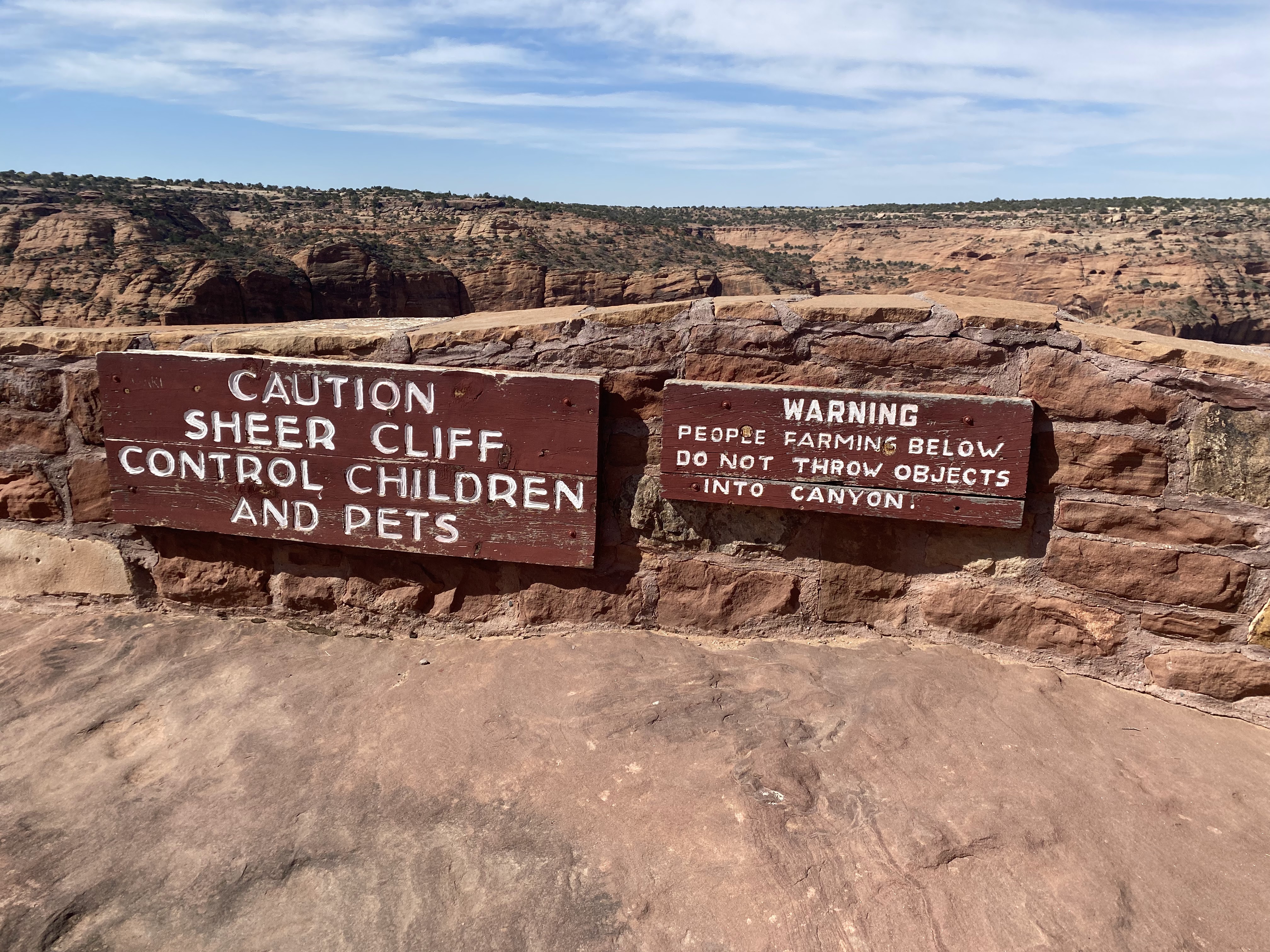
A sign at Canyon de Chelly National Monument (photo courtesy of Professor Lisa Pruitt)

In the winter of 1951, a Norwegian tourist got lost in the Canyon and ended up breaking into two hogans (traditional Diné houses) belonging to a Diné family who lived in the Canyon in the summer. He stole shoes and an overcoat, which he ended up burning by falling asleep too close to the fire. After he was rescued, the Diné family whose hogans he had broken into were upset and demanded repayment for the overcoat. The issue was resolved when the Catholic mission the Norwegian was staying at paid for the coat.

Minor though that incident may seem, it reflects the kind of discomfort that the families living in the Canyon must have felt as an increasing number of tourists came onto their homelands on roads and trails built by the NPS.

More significantly, in 1951, the NPS opted to plant Russian olive and Chinese elm trees in the park to control erosion, despite suggestions that plants indigenous to the area, like cottonwood, might work better. The plants grew well and quickly, to the point that they threatened the archeological sites in the canyon. In 2005, the NPS and the Navajo Nation began working together on the Cooperative Watershed Restoration Project to remove invasive tamarisk and Russian olive trees. The NPS stated that:

aggressive infestation by tamarisk (Tamarix ramosissima, T. chinensis, and their hybrids) and Russian olive (Elaeaganus angustifolia), in combination with intensive historic grazing and tour operations within the riparian corridors of the canyon floor, have created the need for an integrated and collaborative approach to managing all resources (natural and cultural) within the Canyons and their associated watersheds.
The issues identified above are ones that the Diné people living in the canyon have been complaining about since at least the 1950’s and are likely largely because of the NPS actions. The use of tamarisk and Russian olive trees to combat soil erosion was effective. However, the density of the tamarisk root structures made streams cut deeper into the ground. The native plants are less effective at erosion prevention, but allow “braided meandering” that better preserves the characteristics of the canyon.

Relations between the Park Service and the Navajo Nation continue to be rocky. However, as Indigenous land management methods gain greater attention for their ability to help us adapt to and combat climate change, the Park Service is encouraging greater Tribal involvement.

Monday, February 13, 2023

The impact of national parks on rural spaces

The National Park system of the United States includes 423 unique sites spread across the country’s states and territories. A majority of these public parks border rural areas, resulting in unique opportunities and challenges for many small communities across America. 

National parks are often economic and social boons to rural areas. Whitefish is a town in Flathead County, Montana that attracts large crowds during summer months by virtue of its proximity to Glacier National Park. Previous posts involving Glacier can be found here. Despite having a population of roughly 8,000 permanent residents, the town features robust lodging and dining amenities to handle massive crowds, with an extensive downtown area and a ski resort to draw year-round visitation.

With roughly 73 percent of the surrounding Flathead County’s land owned by the federal government, Whitefish is one of the many small cities across the United States experiencing a period of strong economic growth due to its location adjacent to public lands and the natural amenities associated with them.

At the same time, closeness to public lands can strain rural communities past their realistic capacity for population and resources. The resulting gentrification prices locals out of their own communities, in the interests of the tourism industry and wealthy out-of-state residents. Posts from this blog about rural gentrification can be found here. 

However, an often overlooked issue facing rural communities comes from the internet. Social media can transform little-known corners of the country into viral sensations in an instant, overwhelming communities that lack the infrastructure to deal with such population surges. 

An article posted by The Guardian documents the struggles of Kanarraville, a town of only 350 residents located next to Kanarra Falls, a natural slot canyon river located on the same federal tract of land as Zion National Park. Once a relatively unknown destination, the area now sees an annual influx of 40,000 to 60,000 tourists due to the falls’ online notoriety.

Not only does the overwhelming number of visitors consistently overload the town’s resources, but the river itself is a watershed tapped by the town for drinking water. Tens of thousands of guests trek directly through the river on their hike up the canyon every year, leading to sanitation concerns from local residents.

The town of Estes Park sits at the gateway of Rocky Mountain National Park, with tourists flocking from across the country to visit the mountains (and the hotel from The Shining). The Guardian estimates that Estes Park accommodates up to 3 million people over the course of its peak summer months, despite its population of just 5,366. As a consequence, the area features a higher police funding per capita than 97 percent of departments across the country as it struggles to keep the swells of tourists under control.

In order to find a solution for this ever-growing problem, rural communities may want to turn to other countries for inspiration. A publication in the Journal of Rural Studies documents Norway’s efforts to balance nature conservation on public land with local concerns, opting to adopt a process that brings rural areas into the decision making process. Spurred by concerns over what tourism in the name of conservation efforts may mean for people’s livelihoods, Norway has opted to decentralize traditional land management operations in certain municipalities, giving rural voices more power to decide how these parks will be implemented and maintained. 

Breheimen National Park, located on the Skjåk Municipality, is one of the areas receiving this treatment. Breheimen has only been open since 2009, giving locals the unique opportunity to ensure the national park grows in a way that is as responsive to their needs as possible. While the long-term effects of this strategy are yet to be seen, handling such complex situations in this way could work wonders in the United States, giving more agency to rural communities in need.

Monday, October 30, 2023

Tribal co-management of National Parks (Part IV): Big Cypress National Preserve

For the last installment of my National Park co-management series, I'm looking at Big Cypress National Preserve. Big Cypress covers more than 700,000 acres in southern Florida, north of the Everglades National Park. 

Big Cypress National Preserve (Antonio Chavez/Wikimedia Commons)
Big Cypress was the first National Preserve in the United States (Glacier Bay, another National Preserve I covered here, was a National Monument but became a National Park and Preserve in 1980). Parkland designations have a variety of meanings, but in the case of Big Cypress, the "preserve" designation didn't only preserve the swampland, it also preserved the preexisting land uses. Indigenous peoples thus retained their traditional use rights, as did other folks living in the swamp.

Big Cypress is the traditional homeland of the Calusa, Creek, Seminole, and Miccosukee peoples, among others. They have lived in Florida from time immemorial. Before contact with the Spanish, there were many nations and many peoples living throughout the state. After the arrival of the Spanish, disease, violence, and the slave trade decimated Florida's Indigenous population. Those who remained coalesced into broader Creek and Seminole groups. 

During Andrew Jackson's presidency, Congress passed the Indian Removal Act, which invalidated earlier treaties the United States had made with Florida Native peoples. The U.S. Army invaded Seminole territory and marched thousands of Seminole, Creek, and other Southeastern Indigenous people west to land that is known today as Oklahoma. The Seminole fought back for decades, eventually taking up residence deep in the Florida swampland. The US Army assumed that they would die there, and eventually abandoned the fight. 

Instead, the swamps of southern Florida have allowed the Seminole and Miccosukee Tribes to thrive. The Seminole and Miccosukee have several reservations near Big Cypress and enjoy statutory rights to use the federal swampland as they traditionally would. Today, the Seminole Tribe of Florida is likely the wealthiest Tribe in the country. It operates 7 casinos in Southern Florida and owns Hard Rock International, the parent company of the Hard Rock Cafe franchise. Forbes Magazine valued the Tribe and its business holdings at $12 billion. The next richest Tribe in the United States, the Shakopee Mdewakanton Dakota in Minnesota, have an approximate net worth of $2.7 billion.

The homelands of the Seminole and Miccosuke peoples in Big Cypress were first protected because of a massive, futuristic airport project. In 1968, two years before the passage of the National Environmental Policy Act (NEPA), which requires federal agencies to complete environmental impact surveys on proposed projects, the state of Florida proposed the construction of the Everglades JetPort, an airport for the future. Five times the size of JFK International Airport, the Everglades JetPort was designed for supersonic flight. Boeing was working on an American answer to the Concorde, and the JetPort was  to have six runways to land those jets. It would connect to both Florida coasts through a 1,000 foot-wide transportation corridor on either side, capable of "handling tracked air cushion vehicles traveling at speeds of 150 to 250 miles per hour."

As construction began, the undersecretary of the Interior asked Dr. Luna Leopold, the son of Aldo Leopold (author of A Sand County Almenac), to conduct the state of Florida's first Environmental Impact Survey. Dr. Leopold found that the construction of the airport would almost certainly destroy Everglades National Park. The proposed runways would be only six miles north of the Everglades' northern-most boundaries, destroying vital waterways and wildlife corridors for endangered species like the Florida Panther.  

In order to build the airport, Florida would have to fill in thousands of acres of swampland. The loss of swampland would have almost completely destroyed the water flow into the Everglades. Additionally, the Big Cypress swamps allow the  aquifer that provides the drinking water for all of South Florida to re-fill. Building a giant airport would not only jeopardize that process, it would potentially contaminate the ground water with hazardous substances commonly used at airports, like jet fuel.

The reaction to the environmental impact survey was enormous – most of it in opposition to the airport. Construction on the JetPort halted in 1970, after only one runway was built. The federal government acquired the land and established Big Cypress National Preserve in 1973 by an act of Congress.

Perhaps because of the time period in which the Preserve was established, the amount of public support for the parkland designation was remarkable. The project was supported by environmentalists, Tribal interests, and everyone else living there. In addition to the Seminole and Miccosukee, the swamps of south Florida were home to many white settlers who lived off of the swampland. These people, sometimes called Florida Crackers or Gladesmen (or women), were instrumental in the establishment of the Preserve. 

Unlike the other parks I've covered in this series, which were either owned by Tribal Nations or were federal land at the time they became parks, Big Cypress was a conglomeration of private land rights that were purchased expressly for preservation. The designation of National Preserve, the first in the country, preserved preexisting land uses, including Traditional Seminole and Miccosukee practices, as well as fishing, cattle grazing, and oil and gas exploration (note, however, that no new grazing permits are being issued).

What is most remarkable about this project is that it predates quite a lot of important environmental regulation. Much of the Clean Air Act was passed the same year the JetPort project died --1970. NEPA was also enacted in 1970. The Clean Water Act was enacted in 1972. The Endangered Species Act was enacted in 1973. Tribal interests, conservationists, and the people of Florida came together to prevent the construction of this airport before many of the conservation mechanisms we would use today existed. 

They were able to protect Big Cypress using older tools. 

Recently, the Collier Resources Company bought permits for oil exploration in Big Cypress. They gouged hundreds of miles of trails into the park to search for oil and gas reserves using a sonar-based system. Environmental organizations and the U.S. Army Corps of Engineers have spoken out about the damage the exploration has done. The National Parks Conservation Association is campaigning for the government to acquire Big Cypress's mineral rights to prevent any future extraction. 

This is the last post in my series about co-management of National Parks, so I want to offer a few over-arching observations. More so than I expected, co-management is a story of survival and of growth. The four parks I looked at were based on the four parks mentioned in this 2022 speech. Each park is unique and beautiful. Each co-management agreement is similarly unique. 

John Leshy spoke about the unique place that public trust land has in American politics at the California Lawyer's Association's Environmental Law Section Conference this year. (He covered similar topics in this interview) He argued that it can be a uniquely bipartisan issue. The creation of Big Cypress seems to exemplify that. The project was helmed by then-Senator Lawton Chiles, a Democrat, but had broad support across Florida.

I learned from Professor Leshy's talk that co-management is not defined anywhere in public lands law. He implied that this made further proliferation of these agreements more difficult. Though I don't doubt the difficulty of negotiating these agreements, it's possible that the process might make the management agreement fit with each ecosystem better. In each park, the co-management agreement has been different, according to the history, the landscape, and the interests of the Tribe(s) involved. There is no one-size-fits-all solution to land management in the United States. That's a good thing. 

Thursday, October 22, 2020

Two big WaPo stories out of Montana: rural gentrification in (1) the coronavirus era and (2) in politics

Here's the rural gentrification story, which drew sharp criticism out of Montana when it was published yesterday.  The headline is, "New homes on the range: Weary city dwellers escape to Montana, creating a property gold rush," by Lisa Rein.  A lot of the complaining was based on the fact Ms. Rein didn't interview the folks being displaced by urbanites moving to Big Sky Country (also known as the last best place).  But other complaints were based on this statement, which overlooked the significant Black Lives Matter protests in Bozeman, which in many ways is the quintessential example of rural gentrification in the mountain west right now: 

"We are 98 percent Caucasian,” said Candace Carr Strauss, chief executive officer of the Big Sky Chamber of Commerce. “We haven’t, thankfully, seen a lot of the unrest other places have seen.”

Here is more great context, just before that quote in the story:

The mask police lay low. In a hyper-divided country, Montana’s politics are balanced. Its demographics less so, but that is part of the appeal for many who are coming here.

And on the nature of the latest round of gentrification sweeping the state, there's this:

The newest migrants are different. They’re escaping fear, of the pandemic and of the social justice marches they believe are bringing violence to their door. Montana can bring them back in time.

The other story is about the governor's race, in which Greg Gianforte, the Republican who slugged a reporter when Gianforte was running for U.S. Representative two years ago, is challenging a Democratic candidate with much deeper roots in "the Last Best Place."  In short, Gianforte, who made his money far from Montana, represents rural gentrification.  I can only imagine the politics in the state capital if he wins.  Kathleen McLaughlin reports: 

Cooney, 66, is a well-liked Democrat, a sitting lieutenant governor and grandson of a 1930s Montana governor, with decades of public service experience. His opponent is two-term Rep. Greg Gianforte, 59, a Trump-aligned Republican running largely on his credentials as a self-made multimillionaire tech businessman.

* * *  

In a state where voters routinely split the ticket and vote across party lines, retail politics and personal connections have long mattered. The 2020 gubernatorial contest has morphed into something different, led by ad spending and partisan identity centered on President Trump. It is a reflection of the polarization gripping the nation, which now threatens this traditionally bipartisan state.

Gianforte has put $8 million of his own money into the race, and it'll be interesting to see where that gets him.  Meanwhile, outgoing governor Steve Bullock (D) is trying to unseat first-term U.S. Senator Steve Daines (R).  Bullock has been a popular governor who has worked across the proverbial aisle, and it'll be interesting to see where that gets him in a race which, at this point, is very tight. 

And back to gentrification for a moment, don't miss this High Country News piece from a few years ago about Bozeman--and 10 reasons not to move there.

I first visited Montana in 2009 for a "rural law" symposium.  I wound up publishing this article on the challenges of delivering health and human services to rural folks.  I learned so much about Montana geography from that project, which focused on four counties that were rural to varying degrees (Wheatland, Gallatin (Bozeman), Sweetwater, and Big Horn), and one that was urban/metropolitan (Yellowstone County, home to Billings)  Two years later, I returned for my first Big Sky vacation, starting in Glacier National Park (Kalispell (Flathead County) and Browning (Glacier County)) and working my way down to Salmon, Idaho (via Missoula and Darby (Ravalli County)).   In 2016, I returned to Missoula for the Bill Lane Center's Echols Family's Rural West Conference.  Most recently, in 2017, I flew in to Bozeman and worked my way, via Livingston, to Gardiner, on the northern edge of Yellowstone National Park.  From there we made our way into Wyoming, to the Grand Tetons for the total eclipse.  I admit to having my own not so secret desire to move to Montana.  

Thursday, June 15, 2023

My Rural Travelogue (Part XXXIV): Taking care of Iceland's rural roads and providing electric car chargers in remote locales

One thing I noticed on my recent visit to Iceland is how much maintenance I saw on what could only be considered rural roads.  I'm not just talking their Highway 1, on which you can circumnavigate the island.  Because it is two-lane for nearly the entire 16-hour journey, some might consider it rural, but given its high use by tourists and residents, I do not.  I'm talking unpaved (also known as unsealed) roads, like the one that we took south from near Reykholt (the place called Reykholt that is north of Rekjavik, as we were traveling back to Selfoss having been to see the Langjokull glacier) to the northern end of Thingvellir National Park.  Along the way, we were on Road 52 (unpaved for that segment), which meets Road 550 (paved).

There we saw two road graders in action, in addition to several signs indicating road works were in progress.  
Road 52, north of Thingvellir National Park

Road 52, north of Thingvellir National Park


We also saw road works on a minor road near Hella, in South Iceland.  
Near Hella, Iceland

Near Hella, Iceland

In fact, we saw more work on these minor roads--including unpaved ones--than we did on major roads.  I found this interesting in that it suggests the government is making rural transportation a priority.  (A post about the political significance of taking care of rural roads in the United States is here.)  

We also found of interest the electric car charging infrastructure.  Overall, it is not very extensive.  I saw only one bank of perhaps half a dozen Tesla chargers.  That said, there tend to be one or two car chargers in even very isolated places, like Reykholt (see details of location above) and the Highland Center Hraunejay, along a stretch of "highlands" road, seemingly leading nowhere but with a small lodge and dining room, in South Iceland, mostly to facilitate ecotourism to the area.  (We were there for lunch before visiting Haifoss waterfall, and adjacent Granni, meaning neighbor and after hiking into the valley at Gjain).  While we didn't see a lot of electric cars on the road in Iceland, it's clear the charging network will be far flung and ready for them: 

Several charges at Hotel Ranga, near Hella, South Iceland
Charging Station at N1 convenience store, Reykholt, Iceland
(c) Lisa R. Pruitt 2023

Charging stations at Highland
Center Hraunejay, above and below 
(c) Lisa R Pruitt 2023

In comparison, here is what the sole gas pump in Reykholt looked like (the orange electric charger pictured above to next to the minimart, not visible behind the gas pump: 

Convenience store in Reykholt, location of the orange electric car charging station in photo above.
(c) Lisa R. Pruitt 2023
And here is the sole gas pump at the Highland Center: 
Highland Center Hraunejay, South Iceland
(c) Lisa R. Pruitt 2023
Finally, here is a photo of the public transit bus stop in Reykholt; it sits in front of the convenience store pictured above:
Public transit bus stop, Reykholt, Iceland
Speaking of rural transportation, the New York Times reported this story today out of Huron, California, in the central Valley.  Lyft and Uber don't operate there, but it offers electric car share services, as reported by the Los Angeles Times 18 months ago. 

Sunday, November 16, 2008

Persistent poverty and the 2008 rural vote (Part I): Indian Country

Having given some attention to the role of rural gentrification and the rural resort phenomenon on the 2008 race for the White House (here), it seems appropriate also to look at how a different cluster of rural counties voted: those which are persistently poor.


The U.S. Census Bureau uses the term “persistent poverty” to refer to those counties whose poverty rates have been 20% or higher in each decennial census since 1970. (See p. 4 of the USDA ERS publication here). Our nation’s 386 persistent poverty counties are home to 4% of our population. Of these counties, 88% are non-metro, and residents of persistent poverty counties comprise 14% of the non-metro population.


The map of persistent poverty counties from the 2000 Census is shown above (non-metro persistent poverty counties in dark purple), and it indicates that pockets of persistent poverty are in the Mississippi Delta and extending across the black belt; in Appalachian Kentucky and West Virginia; in the Rio Grande Valley; on American Indian reservations in the Plains, and in several counties in the Southwest. A few are scattered through Oklahoma and the Texas panhandle, a few more in the mountains of northwest Arkansas and southeast Missouri. Alaska has wide swaths of persistent poverty, sparsely populated, of course. The northeast has none.


Note that these are only the poorest of the non-metro counties; many others have high poverty rates. Indeed, while the 2007 poverty rate for metro counties was 11.9%, it was 15.4% for non-metro counties.


So, who did voters in these pockets of enduring poverty support in the 2008 race for President? One might expect such populations to be supports of the Democratic Party in light of its embrace of some degree of wealth redistribution to provide a baselie of welfare for all. A casual glance indicates that some regions with persistent poverty overwhelmingly supported Obama; others went for McCain. (You can see the 2008 electoral map here; select "county leaders" in upper left hand corner). Obama supporters tended to be in the Misissippi Delta, black belt, Rio Grande Valley, and in Indian Country. In short, the tended to be voters of color. The McCain voters, on the other hand, were in Appalachia and other parts of the Mid-South.


I’m going to look at some of these regions in detail in a series of posts, beginning with Indian County, in the Great Plains and into the Mountain West. While the American Indian population has a history of leaning Democratic, a look back to ’00 shows that many persistently poor counties in Indian Country voted for Bush that year. They’ve been moving back into the Democratic fold since then, and this month they helped sweep Obama to victory. That is, they helped a little bit. Even where these counties overwhelmingly supported the Democratic ticket, their populations are so small as to have relatively little impact on their states’ total vote counts.


I wrote earlier about some Montana counties that supported Obama, suggesting that the vote there was a product of rural gentrification. In fact, the Montana counties that went for Obama featured varied demographic profiles; among them were three persistently poor counties with large American Indian populations. Among the bluest are three sparsely populated counties on the Canadian border: Glacier (population 13,247), Blaine (population 7,009) and Hill County (population 16,673). Fewer than 5,000 votes were cast in Glacier County, where more than two-thirds of the land is Blackfeet Indian Reservation and one-fifth is Glacier National Park. Sixty-five percent of Glacier County voters supported Obama. In Blaine County, where 45% of the population is American Indian (and, notably, another 26% claim either German or Norwegian ancestry), 58% supported Obama. Big Horn County (population 12,671) on the state’s southern border is also persistently poor and heavily American Indian. Voters there went for Obama in a big way, too – 67%. Roosevelt County, population 10,620, on the state’s eastern edge with North Dakota, is dominated by the Fort Peck Indian Reservation but is not persistently poor. Sixty-one percent of voters there supported Obama. It is worth noting that Glacier, Blaine and Big Horn Counties all voted Democratic in ’00 and ’04, too, but they did so by smaller margins.


In the Dakotas, most of the persistently poor counties voted for Obama. In South Dakota, these include Shannon County (population, 12,466) and Todd County (population 9,040) to the south, and Dewey (population 5,972), Ziebach (population 2,519) and Corson (population 4,181) counties to the north. All five lie entirely within one or more American Indian reservation, and all overwhelmingly supported Obama. Indeed, he won almost 89% of the vote in Shannon County. In addition, Buffalo County (population 2,032), South Dakota, where many Crow Creek Sioux live, 73% of voters supported Obama. Buffalo County has the unfortunate distinction of being the poorest county in the United States with a median income of $12,692, and a per capita income of just over $5K. Interstingly, several of these poor American Indian areas supported Bush in ’00, though Bush had lost most of that support by ’04.


In North Dakota, three of five persistently poor counties opted for Obama. Sioux (population 4,044) , Benson (population 6,964) and Rolette (population 13,674) counties all supported the Democractic ticket, while Grant (population 2,841)and Sheridan (population 1,710) counties went for McCain. The populations of Sioux and Rolette counties are primarily American Indian (85% and 73%, respectively), Benson County is roughly half white, half American Indian; and Grant and Sheridan counties are 96% and 99% white, respectively. Not surprising, then, in light of the evident trend with American Indian voters, Sioux and Rolette counties have been most consistent in supporting Democratic candidates over the past two decades. The extreme population sparsity of Sheridan and Grant counties -- fewer than 3 persons/square mile-- suggests large ranching operations, which would be consistent with fiercely independent, small government ideology, although it would not necessarily be consistent with the low median income (under $25K) and the high poverty level.


Outside the Great Plains, American Indians are somewhat more dispersed. While Arizona and New Mexico have significant American Indian populations living in persistent poverty counties, those counties often have large Hispanic populations, too. Because the racial and ethnic mix of these counties differs so greatly from the more concentrated pockets of American Indians in the Great Plains, I will discuss these in a separate post.


A 2007 book, Native Vote, offers an in depth analysis of the burgeoning significance of the American Indian vote, particularly in state and local contests. The authors are Daniel McCool, Susan M. Olson, and Jennifer L. Robinson, all of the University of Utah.

Monday, September 26, 2011

Rural states that cry “Wolf!”

After hundreds of years of eradication by unrestricted hunting and habitat destruction, the grey wolf population in the United States has been making a small comeback.

The Federal Government, under the Endangered Species Act, has sought to reintroduce wolves to areas that can support them. These efforts have been limited to very rural areas with lots of remote federal or state controlled land because wolves need space, natural food sources, and limited human interaction to thrive.

It is estimated that the U.S. has well over 9,000 wolves. Alaska has the most with an estimated 6,000 to 7,000 wolves. Minnesota has about 2,900 with some spreading out into Wisconsin and the upper peninsula of Michigan. Both of these states never lost their native populations and were deemed not in danger of extinction. Both have been allowed to manage their wolf populations with limited federal intervention, management that includes limited hunting.

Problems have arisen, however, in states that have had wolves successfully reintroduced: Montana, Wyoming, and Idaho. Wolves were wiped out in all three, but through reintroduction and some natural migration from Canada, an estimated 1,700 wolves now roam in the Northern Rockies and Yellowstone National Park today, up from an estimated 1,200 in 2006.

The original federal plan was to bring the wolf population in the Rockies up to 300. The plan was crafted with input from ranchers, land owners, conservationists, and animal rights activists about the impact wolves would have on local areas and the conditions needed for successful reintroduction.

The success of the protection plan created a population nearly six times the originally planned 300. The population is now big enough to prompt the federal government to remove the wolf from the protection list in those states and call the effort a great success. The de-listing gave the states the right to manage wolves in all areas within their borders except within the boundaries of Yellowstone and Glacier National Parks.

When the wolf was first de-listed in 2008, all three states rushed to implement the wolf management plans that they had submitted to U.S. Fish and Wildlife prior to the de-listing. All three states submitted plans that included hunting wolves. These pro-hunting plans came about in part because of intense pressure from ranchers (angry about livestock killed by wolves) and hunters (both hunters who wanted to hunt wolves and hunters who complained of reduced populations of other game animals because of wolf predation).

These plans came under intense scrutiny by animal rights groups. These groups sued to stop the hunts. Federal District Court Judge Donald Molloy agreed with the animal activists that the revised plan violated the Endangered Species Act and issued an injunction to stop the planned hunts and state management of the wolves. Judge Molloy deemed the populations were too fragile to be managed by the states and opined that the wolves required continued protection by the federal government.

Before leaving office, the Bush Administration again removed the wolf from the protected list in January 2009, but did agree that Wyoming’s wolf population was too weak to support hunting and kept those wolves on this list. Judge Molloy countered in 2010, finding again that the plans violated the Endangered Species Act, but not before planned wolf hunts occurred in Montana and Idaho in 2009. In response to Judge Molloy’s second ruling, U.S. Senator Jon Tester (MT) and U.S. Representative Mike Simpson (ID) added a provision to a 2011 spending bill that again de-listed wolves in Idaho and Montana. This of course has spawned a new round of lawsuits. A U.S. District Court judge in Montana granted a summary judgment in favor of the government on August 3, 2011. Yet the judgment is sure to be appealed.

The ruling caused quite a row about federalism, separation of powers, and the role of law in conservation efforts. A friend of mine once asked “who is better at wildlife management: the U.S. Fish and Wildlife Service and the respective state agencies filled with biologists and game management experts… or is it a Federal judge with no ‘practical’ experience?” Of course my friend conveniently forgot that Judge Molloy was a native and lifelong resident of Montana who probably has lots of “practical” rural legal experience.

There is a lot of anger and rhetoric being tossed around. Rural Idaho, Montana, and Wyoming are heavily dependent on ranching and hunting for revenue. Ranchers are angry about predation by wolves that not only kill valuable stock, but also put stress on living stock that results in lost weight and health. Hunters are angry because wolves have put a large dent in elk and deer populations in some wilderness areas, prompting them to find other places to hunt. Elk hunts generate between $600 and $1,000 per hunter in fee revenue alone, let alone the private economic impact of guide and butchering profits. The temptation of fees gathered for wolf licenses and tags in already cash strapped states is also a factor for states.

States also face the conflict of trying to return wilderness areas to their pre-white settlement state. Most Americans want the wild places of U.S. to be as vibrant as the once were, and that vibrant picture should include wolves. To the surprise of some, many hunters side with protecting a healthy wild wolf population. But the size of that population and how to manage it is the dividing force.

Ed Bangs, the man who was in charge of the area's wolf reintroduction for 16 years, stated in 2011 upon his retirement from the U.S. Fish and Wildlife Service that “The best science clearly documents that wolves are fully recovered and will not be threatened in the future. We are rock solid… It’s time to move on.” ( Bugle, Vol. 28, Issue 5, Pg. 63, Sep/Oct 2011) But it is unclear in the emotional and legal tug-o-war that is occurring in this rural area if we ever will move on. And as wolves are being reported in Oregon and Washington, it is a struggle that appears will be affecting more rural areas in the future.

See these related posts: